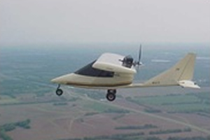
BuckEye
NEANY's customer is the Army Corps of Engineers, Army Geospatial Center (AGC). NEANY began converting the Titan Aircraft Tornado II kit plane to a UAS in 2003. NEANY was awarded a prime contract in 2007 to integrate and flight test the 235 pound BuckEye LIDAR system on the Arrow. The BuckEye received the 2006 Army Invention of the Year Award.
Mission Support
Three NEANY employees and two BuckEye Arrows have been conducting mapping/surveillance missions in Afghanistan since June 2010. An additional NEANY team is preparing to deploy to another location in Afghanistan to work in a hub and spoke configuration.
Applications
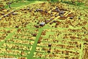
A digital color camera provides enhanced situational awareness, mission planning, visualization, fixture identification, while a Light Detector and Ranging (LIDAR) sensor collects high-resolution, high accuracy elevation data that can be used to generate 3D views. Uses for LIDAR/elevation data and 3D views include:
- Analyze vertical obstructions and slopes for mission planning
- Identify near-exact X, Y, and Z coordinates for targeting
- Calculating volume for flood modeling
- Urban planning
- Real estate
- Agribusiness